

Forecast hour +4
Tue 15 Sep, 06:10
Generated 02:17Weather detail
- Forecast assessment
- Marginal because upper wind range reaches 18.4 kt.
- Wind change
- Rapidly decreasing (-5.4 kt)
- Direction-change risk
- 100%
- Weather regime
- Showery / unstable
- Provider agreement
- Significant disagreementSource wind spread 5.4 kt; direction spread 71°.
- Selected sources
- Corrected 100%
Gust probability
18+ kt98%
20+ kt97%
25+ kt80%
30+ kt67%
TBSC course selection
Short course270° magnetic
Why this course set?Short selected because the forecast mean is 13.8 kt and gust 21.0 kt, outside the Force 3-4 band; the card uses Short for Force 1-2 or Force 5 conditions.The 272 degree true forecast converts to approximately 273 degrees magnetic and uses the nearest 15 degree matrix column: 270 degrees.
| Fleet | Course |
|---|---|
| Oppy 2 | 1Y |
| Optimist | 2 |
| Feva | 8 |
| Slow Misc | 8 |
| Myth | 8 |
| Misc | 20 |
| 1/2 Rater | 20 |
| Start | G/W |
Wind-based selection; shorten for poor visibility, rough sea or other race-management concerns.
Trearddur Bay Sailing Club
Sailing area
Tue 15 Sep, 06:10 · Wind W 272 deg T at 13.8 kt, gust 21.0 kt · Short course, 270 deg magnetic
Course overlay ready
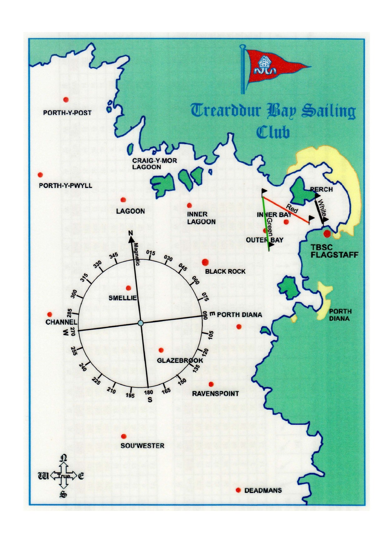
Course 1YOppy 2Route diagram referenced as page 27 but not included in the supplied scan
Why: The 2026 selector assigns Course 1Y to Oppy 2 for this course length and magnetic-bearing column. Its route refers to page 27, which was not included in the supplied scan.
Course 2Optimist4 rounds · Outer Bay · start G/W
Why: The Short matrix at 270 degrees magnetic assigns Course 2 to Optimist. The normal published mark sequence applies. The route starts at the midpoint of the G/W line, uses Outer Bay as its Bay Mark and finishes at the midpoint of the white line.
Course 8Feva2 rounds · Green Bay · start G/W
Why: The Short matrix at 270 degrees magnetic assigns Course 8 to Feva. The normal published mark sequence applies. The route starts at the midpoint of the G/W line, uses Green Bay as its Bay Mark and finishes at the midpoint of the white line.
Course 8Slow Misc, Myth2 rounds · Outer Bay · start G/W
Why: The Short matrix at 270 degrees magnetic assigns Course 8 to Slow Misc, Myth. The normal published mark sequence applies. The route starts at the midpoint of the G/W line, uses Outer Bay as its Bay Mark and finishes at the midpoint of the white line.
Course 20Misc1.5 rounds · Green Bay · start G/W
Why: The Short matrix at 270 degrees magnetic assigns Course 20 to Misc. The normal published mark sequence applies. The route starts at the midpoint of the G/W line, uses Green Bay as its Bay Mark and finishes at the midpoint of the white line.
Course 201/2 Rater1.5 rounds · Inner Bay · start G/W
Why: The Short matrix at 270 degrees magnetic assigns Course 20 to 1/2 Rater. The normal published mark sequence applies. The route starts at the midpoint of the G/W line, uses Inner Bay as its Bay Mark and finishes at the midpoint of the white line.
The blue wind arrow points downwind; its label states the direction the wind comes from. Each coloured course begins at the midpoint of its selected Red or G/W start line and ends at the midpoint of the white finish line. Coloured arrowheads show the order of travel. Lines show the mark sequence once; follow the number of rounds in the key. Published port/starboard rounding instructions remain authoritative.
Forecast sources
| Source | Wind | Gust | Direction |
|---|---|---|---|
| Local | 19.2 kt | 34.8 kt | SSW 201° |
| Corrected | 13.8 kt | 21.0 kt | W 272° |
| Met Office | 14.0 kt | 19.9 kt | W 272° |
| Persistence | 19.2 kt | 34.8 kt | SSW 201° |
| Residual Shadow | 15.7 kt | 21.1 kt | W 272° |
Guidance only. The race officer's decision, current observations, sea state, visibility, tide, official warnings and local safety procedures take precedence over this experimental forecast.